TEHRAN
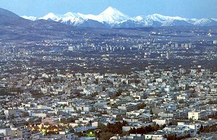
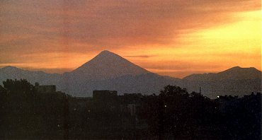
As well as being the provincial capital, Tehran is also the political, economic and intellectual capital of Iran. The city is situated at the foothills of the Alborz mountain range, and its province extends from the southern slopes into the Dasht-e Kevir desert. The highest peak in the Alborz range, Mount Damavand (5,671 metres, 18,600 feet) is an extinct volcano, which dominates the skyline of Tehran. It is Holocene in age which means it probably has been active in the last 10,000 years. A 1,300 foot (400 m) crater is at the summit of the mount and it usually contains a lake. Damavand is popular with skiers, mountain climbers and walkers. It also holds a special place in Iranian folklore. The legend associated with it, is that of the evil ruler Zahhak, who was imprisoned in the volcano by the hero Feraydun (with the help of Kaveh, the Blacksmith). Today, at the first signs of any tremor, the local villagers still say that Zahhak is trying to escape. The region around the modern city of Tehran has a long history. Remains of Neolithic settlements have been found in the small town of Shahr-e Ray, (about ten kilometres south of Tehran). The beginnings of Tehran are unclear but probably occurred sometime in the 11th century. It is believed that, as Tehran had a pleasant climate and was green and fertile, it often came under attack from highwaymen. In order to protect themselves, the villagers made underground dwellings. Hence, the name Tehran (Tah - Ran), meaning "underground town" (Tah meaning under, Ran meaning town or place) 1. The village was situated north of the ancient city of Ray. During the Achaemenian Dynasty, Ray was an important settlement. The Seleucids rebuilt the city and it had great importance under the Parthians and the Sassanians. In 1220, after the Mongols sacked Ray, Tehran began to develop in its place as a small, but moderately prosperous trading centre. Descriptions from foreign travellers in the 15th century mention the existence of a well-established town, but it was not until the reign of the Safavid ruler Shah Tahmasp I (1571-1629) that it was protected by a fortified wall. Shah Tahmasp rebuilt the bazaar and added a citadel or arg in the centre. In 1618, the traveller Pierre d'Laval observed that one third of the land inside the wall was allocated to houses and two thirds to orchards and gardens. The town was also filled with plane trees, and was known as Chenarestan (Plane Tree Town). (The plane tree still lines many streets, roads and avenues in Tehran today.) Tehran became a capital in 1789, under Qajar rule, replacing Shiraz in that function, and in 1796, Aqa Muhammad Khan was enthroned there. His successor, Fath Ali Shah (1797-1834) continued the transformation of the town and had the Shah's Mosque (today, the Imam Khomeini Mosque) and Golestan Palace built, while Nasir ad-Din Shah (1848-96) enlarged the walls and commissioned the Sepahsalar Mosque. During the 19th century, the centre of the city remained focused around the palace and the bazaar. However, Reza Shah (1925-1941) preferred to live in his palaces to the west of the town or in those of Sa'ad Abad, 10 kilometres to the north, and large avenues were cut to link these areas together during his reign. This was the beginning of the vertical north-south axis, which is so characteristic of Tehran. The modern city is huge and expanding rapidly. Its population continues to increase and is now around 12 million (in 1923 it was only 210,000). Along the foothills of the Alborz mountains, remnants of old villages are fighting a losing battle against the mansions and apartment blocs of the wealthy. Tehran's seemingly insurmountable traffic adds to the air pollution in the hot summer months. Most Tehranians escape the heat by heading for the hills around northern Tehran. Here they relax in the many tea-houses, where mountain streams run among the tables.
Mount Damavand from southwest of Tehran
1) Ran: - According to the historian Ahmad Kasravi's book (The Names of Towns and Villages of Iran), the word 'ran' occurs in many compound names of places, with some changes in pronounciation ('raam', 'lan', 'ram') and must mean "town" or "place". He has given as an example the name of one of Tehran's northern suburbs "Shemiran" (Shami - Ran). Shami means cold; therefore 'Shami'-'ran' means cold town or cold place.
Copyright shall at all times remain vested in the Author. No part of the work shall be used, reproduced, stored in a retrieval system, or transmitted in any form or by any means electronic, mechanical, photocopying, recording or otherwise, without the Author's express written consent. Copyright © 2000 K. Kianush, Art Arena |
||||||||||||||